Accurate and up-to-date crop acreage data is essential for effective agricultural planning, policymaking, and market forecasting. Crop acreage refers to the total area of land cultivated with a particular crop during a given season or year. Understanding these data helps farmers, government agencies, agribusinesses, and researchers make informed decisions that optimize production, manage resources efficiently, and support food security goals.
Importance of Crop Acreage Data
Crop acreage data provides a foundational metric for assessing the agricultural landscape and trends over time. Some of the key benefits include:
- Resource Allocation: Governments and agricultural agencies use acreage data to allocate inputs such as seeds, fertilizers, water, and extension services effectively.
- Market Forecasting: Agribusinesses rely on acreage information to predict supply levels, estimate potential yields, and adjust procurement and pricing strategies.
- Policy Formulation: Accurate acreage statistics enable policymakers to design subsidies, minimum support prices, and crop insurance programs tailored to farmers’ needs.
- Food Security Planning: Monitoring crop acreage helps anticipate production volumes, enabling timely interventions to address shortages or surpluses.
- Research and Development: Scientists use acreage trends to identify shifts in cropping patterns and develop improved crop varieties suited to emerging needs.
Sources of Crop Acreage Data
Obtaining reliable crop acreage data involves various methods and technologies:
- Field Surveys:
Traditional ground surveys conducted by agricultural departments or statistical agencies involve visiting farms to record the crop area planted. While detailed, this method can be time-consuming and expensive. - Remote Sensing and Satellite Imagery:
Advances in satellite technology allow for large-scale monitoring of crop acreage. Remote sensing uses spectral signatures of crops to classify land use and estimate cultivated areas accurately. This method provides timely and cost-effective data over vast regions. - Farmer Self-Reporting:
Some governments and organizations collect acreage data through farmer declarations, using mobile apps or paper forms. While this can provide localized insights, data accuracy depends on farmers’ honesty and awareness. - Agricultural Census and Surveys:
Periodic agricultural censuses compile comprehensive acreage and production data at national and sub-national levels, serving as important references for long-term trends.
Trends in Crop Acreage Data Analysis
Recent years have seen significant changes in how crop acreage data is collected and analyzed:
- Integration with Yield and Production Data: Combining acreage with yield estimates provides a clearer picture of total production and food availability.
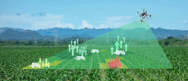
- Real-Time Monitoring: The use of drones and near real-time satellite data enables dynamic tracking of crop acreage changes within a growing season.
- Big Data and AI: Advanced data analytics and machine learning help interpret complex acreage patterns, identify anomalies, and predict future planting decisions.
- Geo-Spatial Mapping: Geographic Information Systems (GIS) map crop acreage data spatially, supporting regional planning and disaster management.
Applications of Crop Acreage Data
- Crop Planning and Rotation:
Farmers and agronomists use acreage data to plan crop rotations that maintain soil health, optimize nutrient use, and manage pest cycles. Understanding which crops dominate acreage helps design sustainable farming systems. - Supply Chain Management:
Processors, traders, and exporters analyze acreage data to anticipate raw material availability, manage inventories, and reduce post-harvest losses through better logistics planning. - Climate Impact Assessment:
Tracking acreage shifts over time reveals how climate variability, water availability, and extreme weather events influence cropping patterns and farmer behavior. - Investment and Risk Assessment:
Financial institutions and insurers use acreage data to evaluate credit risk and design crop insurance products tailored to regional cropping patterns.
Challenges in Crop Acreage Data Collection
Despite technological progress, challenges persist in acquiring and using crop acreage data effectively:
- Data Accuracy: Variability in crop identification, especially in mixed cropping systems, can lead to errors in acreage estimates.
- Timeliness: Traditional survey methods may result in outdated data that limits timely decision-making.
- Data Accessibility: In some regions, data may be restricted or fragmented across multiple agencies, hindering integrated analysis.
- Farmer Participation: Reluctance or lack of awareness among farmers to report accurate acreage data affects reliability.
Efforts to overcome these challenges include adopting standardized methodologies, enhancing farmer outreach, and leveraging modern remote sensing technologies.
Case Study: Using Crop Acreage Data for Effective Food Security
In India, crop acreage data plays a crucial role in the government’s food security framework. The Ministry of Agriculture uses acreage statistics to forecast production of staple crops like rice and wheat, which informs procurement and buffer stocking strategies. Satellite-based acreage estimates complement ground surveys to ensure accuracy and timeliness, enabling rapid response to potential shortfalls caused by adverse weather.
Similarly, in the United States, the Department of Agriculture publishes monthly crop acreage reports that influence commodity markets and inform farm subsidy programs. These reports are widely used by farmers, traders, and policy analysts.
The Future of Crop Acreage Data
Looking ahead, crop acreage data collection and analysis will benefit from continued innovation:
- Enhanced Satellite Technology: Higher resolution and more frequent satellite imagery will improve crop classification accuracy and monitoring capabilities.
- Integration with IoT: Combining acreage data with sensor networks measuring soil moisture, pest incidence, and crop health will provide holistic insights.
- Crowdsourcing and Mobile Technology: Empowering farmers with mobile tools to report acreage and crop status will increase data granularity and relevance.
- Global Data Sharing Platforms: Collaborative platforms that share crop acreage data across borders will enhance global food security and trade analysis.
Conclusion
Comprehensive crop acreage data is a cornerstone of modern agricultural management and planning. It enables better resource allocation, market intelligence, policy-making, and food security strategies. As agriculture faces increasing pressures from climate change, population growth, and market volatility, accurate and timely crop acreage data becomes ever more critical.
Investing in innovative data collection methods and fostering collaboration among stakeholders will ensure that crop acreage data continues to drive efficient, sustainable, and profitable agriculture worldwide.