The Atlas Mountains are one of Africa’s most remarkable mountain systems, stretching across the northwestern part of the continent. Extending approximately 2,500 kilometers (1,550 miles), these mountains pass through Morocco, Algeria, and Tunisia.
Creating a natural barrier between the Mediterranean coast and the Sahara Desert. Understanding the map of the Atlas Mountains in Africa helps travelers, students, and geography enthusiasts appreciate the region’s diverse landscapes, cultures, and ecosystems.
Geographic Overview
The map of the Atlas Mountains in Africa forms a vast chain that begins near Morocco’s Atlantic coastline and continues eastward through Algeria before reaching northern Tunisia. This mountain range is divided into several sections, each with unique geological features and climates. While the western portion receives significant rainfall, the eastern regions gradually become drier as they approach the Sahara.
On a regional map, the mountain chain appears as a sweeping arc across North Africa. It separates fertile coastal plains from the arid desert interior, making it one of the continent’s most important natural landmarks.
Major Sections of the Atlas Mountains
The Atlas Mountains consist of several distinct ranges rather than a single continuous chain. Each section contributes to the region’s natural beauty and ecological diversity.
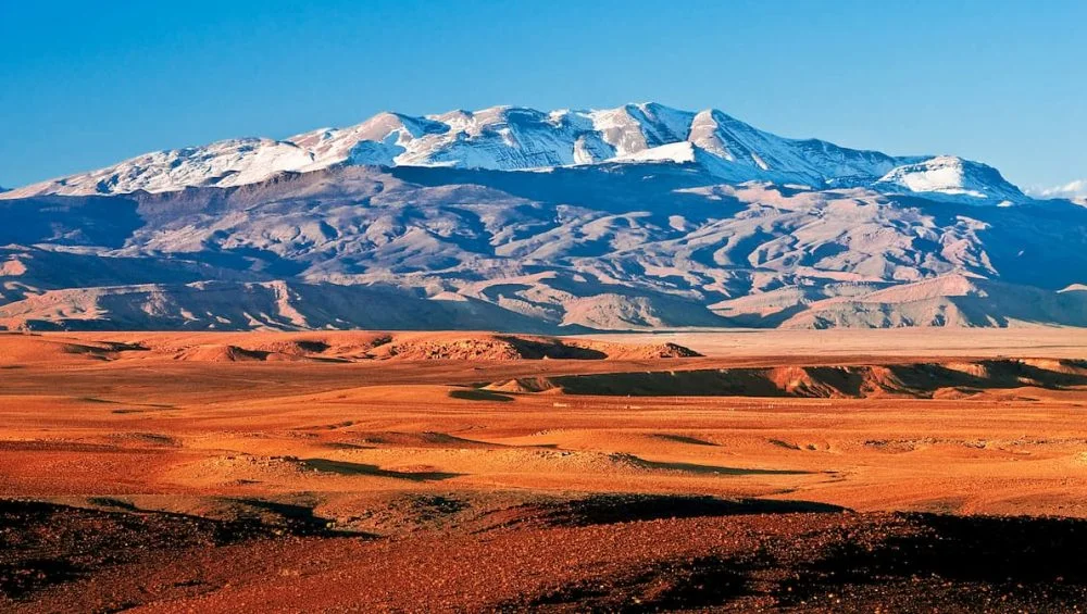
High Atlas
The High Atlas is the tallest section of the mountain system and is located entirely in Morocco. It contains North Africa’s highest peak, Mount Toubkal, which rises to 4,167 meters (13,671 feet). Snow covers many of its peaks during winter, providing water for nearby valleys and rivers throughout the year.
This area attracts hikers, climbers, and nature lovers from around the world due to its dramatic scenery and traditional Berber villages.
Middle Atlas
Situated north of the High Atlas, the Middle Atlas features rolling hills, cedar forests, and freshwater lakes. The region is home to the endangered Barbary macaque, one of the few wild monkey species found outside Asia.
The Middle Atlas experiences a cooler climate than much of North Africa, making it an important agricultural and forestry region.
Anti-Atlas
The Anti-Atlas lies south of the High Atlas and consists of older, lower mountains with rugged rock formations. Although less elevated, the area offers spectacular desert landscapes, ancient villages, and unique geological formations.
The Anti-Atlas serves as a transition between fertile mountain regions and the expanding Sahara Desert.
Saharan Atlas
Crossing northern Algeria, the Saharan Atlas forms a series of mountain ridges that parallel the desert. These mountains influence rainfall patterns and support small farming communities despite the surrounding dry climate.
Many valleys within the Saharan Atlas have been inhabited for centuries because of reliable water sources and fertile soil.
Tell Atlas
The Tell Atlas extends along the Mediterranean coast through Algeria and into Tunisia. This range experiences the highest rainfall in the region, supporting forests, agriculture, and diverse wildlife.
Because of its proximity to the sea, the Tell Atlas enjoys a mild Mediterranean climate that differs greatly from the harsher desert conditions farther south.
Countries Connected by the Mountain Range
The Atlas Mountains unite three North African nations through shared geography and history.
Morocco
Morocco contains the largest and highest portion of the mountain system. Numerous rivers originate in these mountains, supplying water to cities, farms, and hydroelectric projects. Traditional Amazigh (Berber) communities continue to preserve their cultural heritage in remote mountain villages.
Algeria
Algeria contains extensive sections of both the Tell Atlas and Saharan Atlas. These mountains play a significant role in agriculture, biodiversity, and regional climate. Many valleys support vineyards, orchards, and cereal crops because of the fertile soils and seasonal rainfall.
Tunisia
The eastern end of the mountain chain reaches northern Tunisia, where elevations gradually decrease. Although smaller than the Moroccan ranges, these mountains remain important for wildlife conservation, farming, and tourism.
Studying the map of the Atlas Mountains in africa makes it easier to understand how these three countries are physically connected despite their political borders.
Climate and Natural Environment
The Atlas Mountains create several climate zones within a relatively short distance. Northern slopes receive abundant rainfall from Mediterranean weather systems, while southern slopes become progressively drier toward the Sahara.
Higher elevations experience snowfall during winter, while lower valleys enjoy mild temperatures suitable for farming. This variation allows forests, grasslands, orchards, and desert vegetation to exist within the same mountain system.
The mountains are home to cedar, pine, oak, and juniper forests. Wildlife includes Barbary sheep, Barbary macaques, foxes, eagles, and numerous migratory bird species.
Importance to Local Communities
For centuries, the map of the Atlas Mountains in Africa has supported millions of people through agriculture, livestock grazing, and trade. Mountain streams provide irrigation for crops such as olives, almonds, figs, apples, and cereals.
Traditional villages built from stone and mud bricks blend naturally into the surrounding landscape. Many residents continue practicing ancient customs, producing handmade carpets, pottery, jewelry, and textiles that reflect generations of craftsmanship.
The mountain passes have historically connected inland communities with coastal trading centers, encouraging cultural exchange across North Africa.
Tourism and Outdoor Activities
The Atlas Mountains offer numerous opportunities for adventure tourism and cultural exploration. Hiking trails lead visitors through forests, valleys, waterfalls, and remote villages. During winter, some areas even provide skiing opportunities, an unexpected attraction in Africa.
Visitors also enjoy exploring local markets, historic kasbahs, and traditional Amazigh settlements while experiencing authentic regional cuisine and hospitality.
Photography enthusiasts appreciate the constantly changing scenery, from snow-covered peaks to rocky canyons and green valleys.
Why Maps Matter
A detailed mountain map allows travelers to understand elevation changes, transportation routes, protected parks, and nearby cities. It also highlights how the various mountain ranges connect across national borders.
For students, maps provide valuable insight into how geography influences climate, agriculture, settlement patterns, and biodiversity. Researchers use detailed topographic maps to study erosion, water resources, and environmental conservation throughout North Africa.
Understanding the map of the Atlas Mountains in Africa also helps explain why the region has supported civilizations for thousands of years despite its proximity to one of the world’s largest deserts.
Conclusion
The map of the atlas mountains in Africa shows its most significant natural features, stretching from Morocco through Algeria and ending in Tunisia. Their varied landscapes, rich ecosystems, and cultural importance make them an essential part of North African geography.
Whether viewed for educational purposes, travel planning, or environmental research, the mountain system demonstrates how geography shapes history, climate, and human life. A well-designed map offers a clear picture of this remarkable mountain chain and its enduring importance across the continent.